1 Main Categories of Water Landscape
With plentiful forms and distinctive features the water landscape in the park may distribute in carbonate rock regions or in granite regions. In particular a combined landscape of beaches waterfalls and ponds of the Eighteen Moon-like Ponds stands out highlighting the feature of typical waterfall ponds at high mountains.
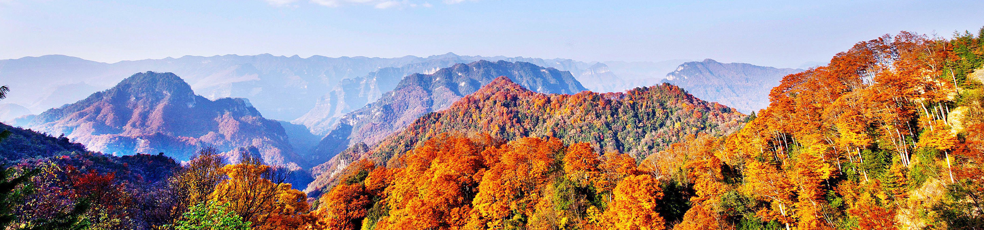
Eighteen Moon-like Ponds: located in the Pearl Valley developed in granite with an overall east-west distribution it is named Eighteen Moon-like Ponds for the eighteen fairyland-like waterfall ponds densely distributed within the valley. The ponds are of different shapes and sizes and the water is clear. In spring the Eighteen Moon-like Ponds like a natural oxygen bar with laminated forests; in summer the mountains are full of rhododendrons and it becomes a summer resort; in autumn the mountains are red all over and there are silver splashes from the waterfall; in winter basically all the trees are covered by snow and snowfields and mountains seem endless.
Wedding Dress Waterfall: located within the Eighteen Moon-like ponds it is about 50 meter high falls in three wave-like levels along the granite ridge with a narrow top and a wide bottom looks like a wedding dress worn by a bride hence the name. The splashing waves are white soft and unique. (Photo B-2-17)
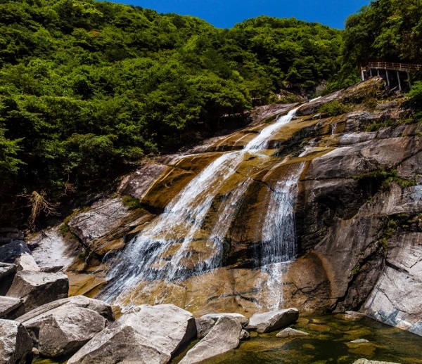
Photo B-2-17 Wedding Dress Waterfall
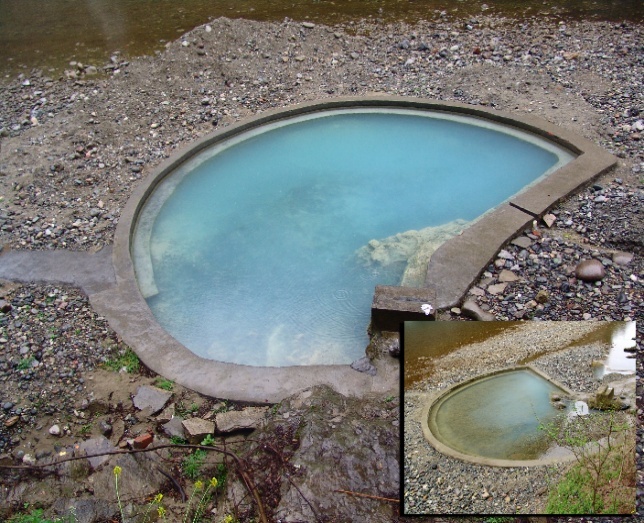
Photo B-2-18 Magical Spring (on a different weather)
Magical Spring: located near the outlet of the subterranean river of the Longhu Cave with an elevation of 540 meters it is also known as the black and white spring. The spring water in black gushes out from the bottom of the river and becomes white when precipitating. The two waters merge together and become milky white from apple green. The spring has three magical features: it changes colors whenever the climate varies milky white on a sunny day and black before rainy weather so it is also called "color-changing spring"; second although it is rich in sulfur its water is cold; third it contains over twenty kinds of chemical materials and more than ten types of micro elements which are quite conducive to the human body (Photo B-2-18).
2 Rivers and hydrological characteristics
The rivers in the Geopark belong to the Jialing River System a tributary of the Yangtze River. The region belongs to the Donghe River of the upper tributary of Jialing River and Nanjiang River and Tongjiang River of the upper tributaries of Qujiang River. There are four main rivers including Nanjiang River Jiaojia River Datongjiang River and Xiaotongjiang River as well as their tributaries within the region.
Nanjiang River is the source of Qujiang River in the Jialing River System. It originates from Yingshui Dam in Nanjiang County at the southern foothill of Daba Mountain located in the junction of Sichuan and Shaanxi. It flows from northeast to southwest. Within the Geopark it runs from Yingshui Dam through Yuquan Guanba and Shangliang and turns southwards at Yinxing Dam through Shatan and Qiaoting and then leaves the park. After that it makes its way through Nianpan downtown of Nanjiang County Dongyu Shahe Chixi and Xialiang leaves Yuantan Community of Yuantan Town enters Bazhou District and merges into the Bahe River at Sanjiang Bazhou. The main stream of the Nanjiang River in Nanjiang County has a total length of 121.7 kilometers a drainage area of 2347 square kilometers and an average annual flow of 52.47 cubic meters per second at the estuary.
Jiaojia River belongs to the largest tributary of Donghe River in Jialing River System while Donghe River which incorporates two major tributaries is a key tributary of the Jialing River that runs through the Micangshan Mountain Range. The source of the east tributary enters the park after running through Yingcui and Mengzi Township and reaches the southern foothill of Micangshan in the dam forest area. After passing through Taoyuan a scenic area in Micangshan it starts to be called Jiaojia River. In a multi-level and extending branch shape it leaves the Geopark at the west boundary of Huaishu Community and enters Wangcang County before merging into Donghe River a tributary of Jialing River. Jiaojia River has many tributaries mainly covering Hanxi River Yingshui Stream Shantang Stream Zhichang River Changping Stream Dalan Valley and Xiaolan Valley. The main stream of Jiaojia River in the Geopark has a total length of 52.3 kilometers a drainage area of 480.16 square kilometers and an average annual flow of 11.4 cubic meters per second at the estuary.
Datongjiang River is the upper main stream of Tongjiang River and is originated in Luojiagou Valley Hexi Township Xixiang County Shaanxi Province. The main stream originates from Huanglong Cave of Daba Mountain and flows from the northeast to the southwest. It enters Tongjiang County at Langjia River. After running through the two estuaries within the county and meeting the Gaozhuang River of the west source it incorporates one after another Mengba River Fazi Stream Gangxi River Xiaoping Stream Yanxi River Yuetan River Jiuyu Stream and Yuanchi River and it merges with Xiaotongjiang River in the lower reaches of Tongjiang County. Datongjiang River flows 142.1 kilometers from its origin to the confluence of Xiaotongjiang River in Xiaojiangkou of which 94.6 kilometers long flows through the county the internal drainage area is 2057.4 square kilometers and the annual average flow is 1.553 billion cubic meters.
Originating from Dahongyan Guangjia Township Nanzheng County Shaanxi Province Xiaotongjiang River is the largest tributary of Tongjiang River. The main part is closer to the west of the Tongjiang Country flows from north to south and runs through the Nuoshuihe Park. It flows through steep valleys and along the river there are dense karst caves. The river flows southwards incorporates one after another Huangjia River Luba River Linjiang River Jinxi Valley Diba River Qingyu Stream Guanlu Stream and Liujia River and merges into the Datongjiang River at the lower reaches of Tongjiang County. The confluence of Xiaotongjiang River and Datongjiang River is 153.8 kilometers of which 108.3 kilometers long flows through the county the internal drainage area is 1102.9 square kilometers and the annual average flow is 833 million cubic meters.
Groundwater in the park mainly includes karst groundwater and me